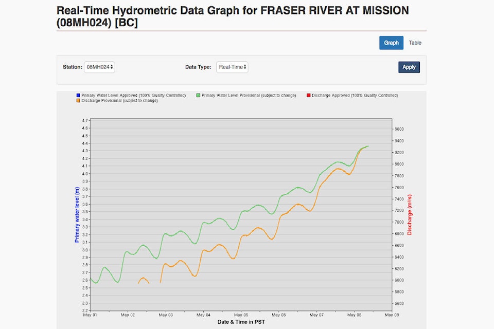
It’s freshet season for the Fraser River, and the snow pack in the Upper Fraser West mountain ranges are around 264 per cent — the highest in the province.
This, according to the May 1 snow pack report, which also notes that dramatic seasonal changes has caused the snow pack to flowing into waterways quickly. Overall, the entire province is sitting at 168 per cent of normal, with flooding and evacuations already taking place in various regions.
While Upper Fraser West is a long way from Chilliwack, the snowpack in that basin flows here eventually. And the levels along the entire Fraser River stretch are all above normal right now.
The May 1 report highlights areas of concern, based on current snowpack, river flows and weather forecasts. The Fraser River at Hope is already high, and will get even higher in days to come, it says. Chilliwack is in the Lower Fraser basin, which is currently at 125 per cent on the snow pack index. During the freshet of 2011, at this time the level was 150 per cent. That year, crops were ruined at Ballam Road as a riverbank collapsed and flood waters breached the land.
READ: Flood ‘preventable’ say Ballam Road residents
The City of Chilliwack starts a program of regular dike inspections when the river level hits 5.5 metres, which ramps up to daily inspections if the level hits 6 metres. They use the Mission gauge, which was at 4.357m on May 8. On May 1, it was at about 2.6m.
It takes about half a day for the water measured in Hope to arrive in Mission.
“Current flow on the Fraser River at Hope (Water Survey of Canada gauge 08MF005) is 7400 m3/s, which is near or above the maximum recorded flow for this early inthe season. Given weather forecasts over the next 10 days the trend of higher than normal flow on the Fraser River is expected to continue. Currently modelling is indicating the potential for flows in the 9,000-10,500 m3/s range at Hope by the middle of May, and the potential to exceed that into the third week of the month.”
The risk is going to remain high across the province for at least another month, and those in areas that normally experience high water during the freshet should be prepared. With snow pack so high, it now comes down to weather patterns, the ministry reports.
“Weather patterns during the snow melt season play a critical role in whether or not flooding occurs…Typically the freshet flood season in British Columbia lasts from early May to late June, and is occurring earlier this year. There is still abundant snow at higher elevations to maintain seasonal flood risk for another month or more.”
Snow pack reports are compiled by the Ministry of Forests, Lands and Natural Resources, based on measurements taken at 222 sites across B.C.
The next snow pack update will be taken in two weeks, with a release to the public on May 22.
As rivers rise, this is also Emergency Preparedness Week in B.C. Residents are encouraged to have a kit ready in case of a natural disaster. Even those not affected directly by a flood, fire, earthquake or other disaster could be left alone without services for up to at least 72 hours. That includes power outages, road closures, and overwhelmed emergency services. To learn more about how to prepare for an emergency, visit the Red Cross website, or Emergency Info BC.
To read the Mission gauge and see the City of Chilliwack response timelines, visit www.chilliwack.com under the Public Safety tab.
Snow Survey May 1 by Jess Peters on Scribd
@CHWKcommunity
jpeters@theprogress.com
Like us on Facebook and follow us on Twitter.
