The impetus for redrawing the map was a bullet going through a window in a densely populated part of the Eastern Hillsides of Chilliwack last fall.
Police confirmed that a stray bullet struck a house on Falls Court near the golf course, after RCMP fielded multiple calls from residents who said they heard gunshots that day in November 2017.
READ MORE: Bullet hits house
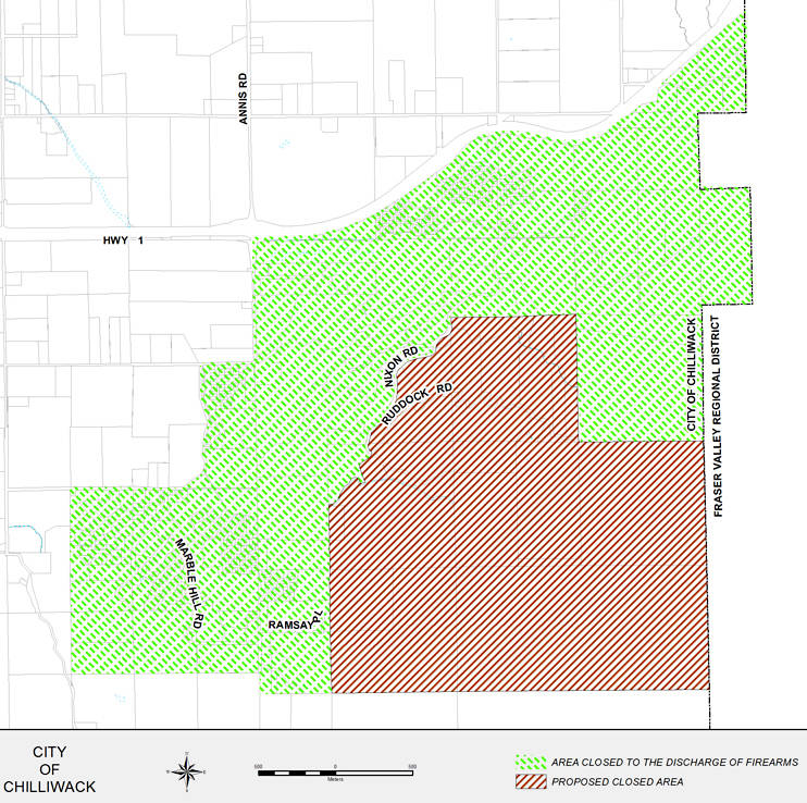
This week city council proposed an expanded area in which the discharge of firearms is restricted in the Eastern Hillsides.
The newly redrawn map shows the additional area being proposed for restriction.
“As the Eastern Hillsides continue to develop and densify, coupled with an incident last November where a house in a densely populated area being struck by a stray bullet, it has become necessary to reevaluate and expand the area in which the discharge of firearms is prohibited within the City of Chilliwack,” according to the staff report from April 3.
Coun. Sam Waddington asked at the Tuesday council meeting if there was a plan by staff for new signage in the Chilliwack River Valley to tell firearms users about the restricted areas.
“I think that would helpful,” said Waddington.
Coun. Jason Lum asked during the meeting why the map changes didn’t include the Vedder Canal and the whole recreational corridor, if council was looking at adjusting the restricted areas. It wasn’t very often that the map is changed, he noted.
City CAO Peter Monteith responded by saying it was likely because there were no shooting complaints from that part of Chilliwack.
A public hearing to update the firearms restricted areas is set for April 17.
@CHWKjourno
jfeinberg@theprogress.com
Like us on Facebook and follow us on Twitter.