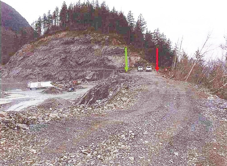
A combination of near-record precipitation coupled with blasting at the Western Explosives Ltd. rock quarry were the likely causes of the Feb. 18 landslide on Vedder Mountain.
A geotechnical consultant hired to look into the causes and recommend measures to mitigate future slides also found that a three-metre high stockpile of blast rock on the top of the slope was a contributing factor.
“Overloading the top of slope with blast rock material while blasting was taking place about 10 metres to the south were likely the main contributing factors,” the report written by engineering consultants WSP Canada concluded.
The report writer recommended that blasting should not be conducted adjacent to the top of the slope until that blast rock is removed.
There is an ongoing Ministry of Energy and Mines investigation into the incident that occurred at approximately 11 a.m. on Feb. 18. The resulting landslide, visible from the valley floor, is approximately 470 metres long and ranges between four and 40 metres wide.
The event threatened the residents who live in a home directly below the slide, but mud and/or rock did not make it all the way down. Still, three homes were evacuated and a protective berm was constructed on Feb. 23 above one residence.
“At 10 a.m. Saturday morning my house shook from yet another blast from the rock quarry on top of the mountain,” resident Scott Gouldsborough posted on Facebook on Feb. 19. “This time it was loud and shook the house.”
Shortly after the incident, Western Explosives’ president Bryan Kirkness said in a press release that there were many factors at play including the weather and a four-magnitude earthquake on Vancouver Island.
“This slide was not caused by blasted rock overloading the dirt slope,” Kirkness said. “The blasted rock was contained within a small area in and around the blast zone, as evidenced by the pictures taken by media and published. Our seismograph on site recorded minimal vibrations at 200 metres away from the blast. It appears ground conditions were unstable from the freezing/thawing and saturated ground. On the north slope ground conditions for unthawing are significantly slower than elsewhere. These conditions can potentially make soils become unstable and potentially sensitive to vibration. Indeed, perhaps the earthquake this morning had an effect of adding more sensitivity to ground conditions, we just do not know.”
After the slide, ministry inspectors issued a written order that blasting be ceased until the investigation is complete, and inspectors were on site on March 8 to review current site conditions, the slopes below the quarry and blasting records.
Kirkness said that in 15 years of operation at the site, this was the first slide on the north slope.
The WSP report forwarded to the City of Chilliwack on March 1, pointed to the severe weather with rain and snow in the 19 days leading up to the slide.
“It is well documented that many landslides are initiated in response [to] rain and snow weather events.”
City hall told the report writers there was a previous landslide in 1999 about 100 metres east of the Feb. 18, 2017 slide and impacted a house at 44100 Vedder Mountain Rd., a property now owned by Western Explosives.
“The house was demolished and not replaced.”
The cause of that slide is unknown, according to the report, however, Western Explosives reports that it may have been caused by a drainage diversion along an old road/trail on the slopes below the north edge of the rock quarry.
paul.henderson@theprogress.com
@PeeJayAitch