The weather story of 2016 had to be the sustained cold snap of December.
It lasted 12 days.
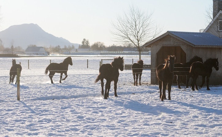
Although mild and wet conditions were the norm in November and in early December, a cold front hit Chilliwack on December 5, ushering in Arctic conditions and snow.
"As the Arctic ridge of high pressure became well-entrenched over the B.C. interior, temperatures plummeted five to 10 degrees Celsius below normal and remained sub-zero for 12 days," reported Roger Pannett, volunteer weather observer for Environment Canada. "It was the longest and snowiest December cold snap since 2008."
After a mild 11.5 degrees was recorded on December 2, temperatures dipped to -10 on December 17, the coldest December temp since the -10 on Dec. 10, 2009. Prior to mid-month Pacific moisture colliding with the cold Arctic air mass produced a 46 cm snowfall over days. On December 19, a marine on-shore flow developed producing some freezing rain before temperatures returned closer to normal for the Christmas period. However a couple of upper level troughs produced two additional snowfalls.
"With residual snow remaining on the ground it was the seventh white Christmas day during the past 27 years."
The other years that saw white Christmases: 1990, 1996, 2000, 2008, 2012, 2015 & 2016.
Four more typical rainy days followed in December before snowy conditions returned on New Year’s Eve, as an upper level trough of low pressure combined with an advancing Arctic cold front.
In terms of an annual recap, after the first frost of the season was delayed from the average November 9 to December 6, and there were 19 frosts in December, which was the highest number since the 24 frosts of December 2009.
For 2016, rainfall totals were 73 per cent below normal, but total snowfall was 198.9 per cent above normal.
With total precipitation 52.75 per cent below normal it was the 18th consecutive December with below normal precipitation.
Despite the December cold snap, it was a warm year overall.
With mean temperatures for 2016 at 1.98 °C above normal, it was the third consecutive year with record breaking high mean temperatures, continuing the warming trend which started in 1986, said Pannett.
In addition to the record-breaking warm April, with mean temperatures an amazing 4.43 °C above normal, there were also eight more months with mean temperatures well above normal and in excess of the 1.1 °C to 2.6 °C standard deviation. On 15 days hot maximum temperatures in excess of 30.0 ̊ C occurred. It was the 15th consecutive year with well above the average 7 hot days, a trend never previously observed. There were a total of 51 record-breaking high temperatures observed in 2016 with only one low temperature record.
Temperature extremes included the record-breaking maximum temperature of 36 degrees, which was 12.4 degrees above normal on August 19, and the low of -10 C on December 17, which was 9.9 degrees below normal.
"Frost totals were 47 per cent below normal and amazingly, for the second consecutive year, there were no frosts in February," he said. "There were a record-breaking 263 frost-free days compared to the 216-day frost free average.
With drier than normal conditions, from March to September, total precipitation for the year was 22.6 per cent below normal. It was the fourth consecutive year with below normal precipitation.